


SPC - No watches are valid as of Thu Apr 25 09:04:01 UTC 2024
No watches are valid as of Thu Apr 25 09:04:01 UTC 2024.
SPC MD 511
MD 0511 CONCERNING SEVERE POTENTIAL...WATCH UNLIKELY FOR PARTS OF SOUTH CENTRAL NEBRASKA THROUGH EASTERN KANSAS AND ADJACENT NORTHEASTERN OKLAHOMA
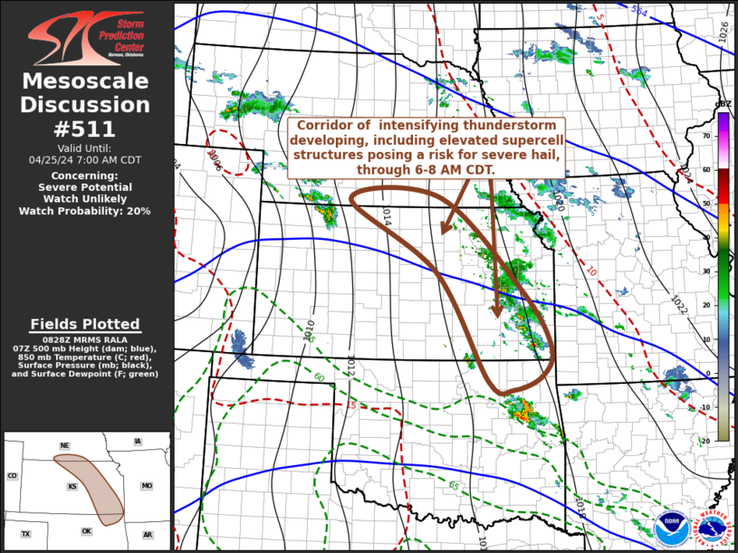
Mesoscale Discussion 0511
NWS Storm Prediction Center Norman OK
0329 AM CDT Thu Apr 25 2024

Areas affected...parts of south central Nebraska through eastern
Kansas and adjacent northeastern Oklahoma

Concerning...Severe potential...Watch unlikely

Valid 250829Z - 251200Z

Probability of Watch Issuance...20 percent

SUMMARY...Developing thunderstorm activity may occasionally
intensify with at least some increase in potential to produce severe
hail through 6-8 AM CDT.  While it still appears unlikely that this
will require a severe weather watch, trends will be monitored for
this possibility.

DISCUSSION...Scattered thunderstorm development is well underway in
response to lift and destabilization associated with elevated
moisture return  within bands of strengthening
lower/mid-tropospheric warm advection across the central Great
Plains.  This is initially focused in corridors across parts of
western Nebraska into northwestern Kansas, and across eastern Kansas
into northeastern Oklahoma, where initial moistening and
destabilization has been weak.  However, more substantive moistening
within the 850-700 mb layer is ongoing across much of western and
central Kansas through eastern Oklahoma, beneath increasingly warm
elevated mixed-layer air advecting east of the southern Rockies.

Into the 11-13Z time frame, the latest Rapid Refresh suggests that
the better low-level moistening may begin to increasingly underrun
the sharpening eastern periphery of the stronger mid-level
inhibition in a corridor roughly from Kearney/Hastings NE through
the Emporia and Chanute KS vicinities.  Based on forecast soundings,
it appears that this may lead to most unstable CAPE increasing in
excess of 1000 J/kg, in the presence of sufficient cloud-bearing
layer shear (beneath 30-50 kt westerly flow in the 500-300 mb layer)
for persistent supercell structures capable of producing severe
hail.

..Kerr/Thompson.. 04/25/2024

...Please see www.spc.noaa.gov for graphic product...

ATTN...WFO...SGF...TSA...OAX...TOP...ICT...GID...

LAT...LON   40209749 38379542 37259470 36689491 36409563 36569624
            38729754 40149974 40209749
Read more
SPC Apr 25, 2024 0600 UTC Day 1 Convective Outlook
SPC 1200Z Day 1 Outlook


Day 1 Convective Outlook
NWS Storm Prediction Center Norman OK
1222 AM CDT Thu Apr 25 2024

Valid 251200Z - 261200Z

...THERE IS AN ENHANCED RISK OF SEVERE THUNDERSTORMS ACROSS PORTIONS
OF THE CENTRAL AND SOUTHERN GREAT PLAINS...

...SUMMARY...
Scattered severe thunderstorms are expected from late this afternoon
into tonight across parts of the central and southern Great Plains.
Very large hail, severe wind gusts, and a couple strong tornadoes
will all be possible.

...Great Plains...

Water-vapor imagery depicts a well-defined short-wave trough off the
southern CA/Baja Peninsula Coast. 70+kt 500mb speed max is forecast
to translate across the northern Gulf of CA early in the period
before advancing into the southern high Plains at 26/00z, and
central KS by sunrise Friday. In response to this feature, lee
surface low will reposition itself into eastern CO by late
afternoon.  While LLJ won't be particularly strong through 26/00z,
boundary layer will moisten significantly across the central High
Plains into northeast CO prior to the approaching jet. Surface
temperatures will warm rapidly across eastern CO such that
convective temperatures will be breached by 21z, favorably timed
with the left exit region of the jet. 60F surface dew points have
spread into the northeast TX Panhandle early this morning, and
should advance into northwest KS prior to expected supercell
initiation. Model forecast soundings exhibit favorable
shear/buoyancy for organized rotating updrafts and the dry line will
be the primary focus for initiation. Very large hail is expected
with this activity along with tornadoes, a few potentially strong.
LLJ will strengthen along the I35 corridor from north TX into NE
during the overnight hours. There will be some propensity for the
western KS convection to spread/develop downstream as low-level warm
advection increases during the latter half of the period.

Farther south along the dry line, it appears a secondary, bimodal
corridor of convection will evolve over west/northwest TX during the
late-evening hours. Deep convection may initially struggle to evolve
along the dry line as some inhibition should linger beyond sunset.
However, large-scale height falls will influence this region by late
evening and profiles will adjust. Thunderstorms are expected to
develop shortly thereafter with initial activity being supercellular
in nature. With time, upscale growth may lead to an MCS-type cluster
that should track northeast across the southern Plains. Very large
hail is possible with the early development, but a transition to
more wind could occur late. Additionally, some tornado risk will
continue overnight despite lifted parcels likely becoming somewhat
elevated.

..Darrow/Weinman.. 04/25/2024


Read more
SPC Apr 25, 2024 0600 UTC Day 2 Convective Outlook
SPC 0600Z Day 2 Outlook


Day 2 Convective Outlook
NWS Storm Prediction Center Norman OK
0100 AM CDT Thu Apr 25 2024

Valid 261200Z - 271200Z

...THERE IS AN ENHANCED RISK OF SEVERE THUNDERSTORMS FOR PARTS OF
EASTERN NE...NORTHEAST KS...WESTERN IA...NORTHWEST MO...

...SUMMARY...
An active severe weather day appears possible on Friday from parts
of Nebraska and Iowa southward into parts of the southern Great
Plains and Ozarks. A few tornadoes (possibly strong), large to very
large hail, and damaging winds will all be possible.

...Synopsis...
A negatively tilted mid/upper-level shortwave trough and attendant
surface low are forecast to move northeastward toward the upper
Great Lakes from Friday into Friday night. A trailing Pacific
front/dryline will move eastward through the day across the
central/southern Plains, before retreating westward Friday night. A
warm front will move northward in advance of the surface low across
MO into parts of IA. Farther west, another deep mid/upper-level
trough will move eastward across the Southwest into the southern
Rockies.

...Eastern NE/KS into western IA/MO...
Supercells capable of all severe hazards appear possible from
eastern NE/KS into western IA/MO, though coverage of the threat with
southward extent somewhat uncertain at this time.

In the wake of morning convection, at least a narrow zone of
moderate destabilization will be possible from parts of eastern NE
into western IA, between the northward-moving warm front and
approaching Pacific front/dryline. Scattered thunderstorm
development is expected during the afternoon, with favorably veering
low-level wind profiles and moderate deep-layer shear supporting
supercell potential. Steep midlevel lapse rates will support a hail
threat, with some potential for very large hail depending on the
magnitude of destabilization. A few tornadoes will also be possible,
both in the vicinity of the surface low, and with any longer-lived
supercells along the dryline into southeast NE/southwest IA.

Farther south, a broader and potentially more unstable warm sector
is expected to evolve across eastern KS into western MO. While
large-scale ascent will be weaker with southward extent, at least
isolated supercell development will be possible along the dryline by
late afternoon. Any sustained supercells within this regime would
pose a threat for tornadoes and very large hail. A strong tornado or
will be possible if stronger pre-convective destabilization can
materialize.

...Eastern OK/northeast TX into AR/southern MO...
Initially strong storm clusters are expected to move across eastern
OK and potentially northeast TX into AR and MO through the morning,
accompanied by at least an isolated hail and damaging gust threat.
Some of this convection may persist or tend to regenerate along the
eastern periphery of the primary instability axis. The eastern
extent of any severe threat remains uncertain, but favorable
low-level and deep-layer shear could support occasionally organized
convection, with an isolated/marginal threat for all severe hazards.

Farther west, moderate to strong instability and deep-layer shear
will support a conditionally favorable environment along the dryline
from eastern OK into northeast TX. In the wake of the departing
shortwave trough, development along the dryline in this area will
likely be very isolated, though any sustained cells would pose a
threat for very large hail and possibly a tornado.

...Edwards Plateau into the Permian Basin vicinity of TX...
As the dryline retreats late Friday night, convection could develop
prior to the end of the period into parts of southwest TX, in
advance of the approaching southwestern trough. Instability and
shear would be sufficient for organized convection, though timing
and coverage of any threat in this area remain too uncertain at this
time for probabilities.

..Dean.. 04/25/2024


Read more
SPC Apr 25, 2024 0730 UTC Day 3 Severe Thunderstorm Outlook
SPC 0730Z Day 3 Outlook


Day 3 Convective Outlook
NWS Storm Prediction Center Norman OK
0230 AM CDT Thu Apr 25 2024

Valid 271200Z - 281200Z

...THERE IS AN ENHANCED RISK OF SEVERE THUNDERSTORMS FOR PARTS OF
CENTRAL/EASTERN KS...NORTHWEST MO...FAR SOUTHEAST NE...MUCH OF
OK...AND PART OF NORTH TX...

...SUMMARY...
Potentially widespread strong to severe thunderstorms are expected
Saturday into Saturday night. The greatest threat is currently
anticipated across parts of the central and southern Plains, where
very large hail, damaging winds, and a few strong tornadoes will be
possible. A larger area of potential threat will extend from
south-central Texas north-northeastward into the Great Lakes.

...Synopsis...
A shortwave trough and attendant surface low are forecast to
gradually weaken and move northeastward across the upper Great Lakes
region on Saturday. Meanwhile, a deep mid/upper-level trough will
move eastward from the Southwest, resulting in a deepening cyclone
across southwest KS. Rich low-level moisture will continue to stream
northward across the warm sector of this cyclone, with favorable
moisture also extending northeast into the Great Lakes region.

...Parts of the central/southern Plains...
While details remain uncertain, scattered significantly severe
thunderstorms may develop across parts of the central/southern
Plains Saturday into Saturday night, with all severe hazards
(including very large hail and a few strong tornadoes) possible.

As the approaching upper-level trough begins to impinge upon the
moist warm sector of the deepening cyclone, strengthening low-level
and deep-layer shear will overspread moderate to locally strong
instability from KS into parts of TX/OK. There is some potential for
early convection to develop and spread from northwest TX into OK.
This early convection would likely pose some severe threat if it
materializes, though it would complicate the scenario for later in
the day.

If the warm sector stays relatively undisturbed, then scattered
supercell development is expected along the dryline by late
afternoon, along with some potential for warm-sector development
farther east, and also near a northward moving warm front across
northeast KS/northwest MO into southeast NE/southwest IA. Very large
hail will be the most likely initial threat, though the tornado
threat will increase with time, as the low-level jet strengthens
through the day. Any supercells that persist into late
afternoon/early evening across the warm sector could pose an
increasing strong tornado threat with time. Some areas may see more
than one round of severe storms, with multiple clusters expected to
develop through the evening, with some threat for all severe hazards
potentially lasting into late evening.

...Great Lakes vicinity...
Coverage of storms into parts of the Great Lakes remains somewhat
uncertain on Saturday in the wake of the departing shortwave trough,
but a conditionally favorable storm environment will likely develop
into the afternoon/evening into parts of WI/IL and MI, as relatively
rich low-level moisture remains in place and deep-layer shear
remains rather strong. Some threat for all severe hazards could
evolve across the region, along/ahead of a cold front, with some
threat potentially lasting into the evening as convection spreads
northeast from the Plains.

..Dean.. 04/25/2024


Read more
SPC Apr 25, 2024 Day 4-8 Severe Weather Outlook
Day 4-8 Outlook


Day 4-8 Convective Outlook
NWS Storm Prediction Center Norman OK
0400 AM CDT Thu Apr 25 2024

Valid 281200Z - 031200Z

...DISCUSSION...
...D4/Sunday - Northeast TX into parts of the upper MS Valley...
Some severe threat is expected persist into D4/Sunday from northeast
TX into parts of the upper MS Valley, as an amplified
mid/upper-level shortwave trough moves from the Great Plains into
the upper Great Lakes region. Substantial convection on D3/Saturday
results in some uncertainty regarding storm evolution on Sunday.
However, guidance generally suggests that a strong mid/upper-level
jet associated with the ejecting shortwave will overspread a
relatively moist warm sector, with potential redevelopment of
organized convection along/ahead of a cold front.

There is some potential for the threat to be bimodal, with one
potential area from eastern KS into northern MO and IA in closer
proximity to the ejecting shortwave, and a separate area across the
ArkLaTex vicinity, within a region of somewhat more favorable
moisture and instability. However, with storm evolution remaining
rather uncertain, a continuous 15% area has been maintained in this
outlook, with some adjustments.

...D5/Monday - Southern Plains into the lower MS Valley...
Guidance generally suggests that a low-amplitude shortwave trough
will move across parts of TX into the lower MS Valley on Monday.
There is some potential for this shortwave to impinge upon a region
of moderate to strong buoyancy along and south of a weak surface
boundary that may begin to lift northward across parts of TX/LA
during the day. A few severe storms with a threat of hail and
damaging winds would be possible in this scenario. However,
uncertainty related to substantial antecedent convection and its
effect on boundary placement renders predictability too low for
probabilities at this time.

...D6/Tuesday - D8/Thursday...
Spread begins to notably increase in extended-range guidance
regarding pattern evolution by D6/Tuesday. In general, stronger
mid/upper-level flow is expected to shift northward, through there
will be some potential for shortwave troughs and related cold fronts
to impinge upon a reservoir of richer low-level moisture and
stronger buoyancy from the southern Plains into parts of the
Southeast/OH Valley. Confidence in the details regarding any severe
potential in this time frame is much too low for probabilities with
this outlook.


Read more
SPC Day 1 Fire Weather Outlook
SPC Day 1 Fire Weather Outlook


Day 1 Fire Weather Outlook
NWS Storm Prediction Center Norman OK
0114 AM CDT Thu Apr 25 2024

Valid 251200Z - 261200Z

...CRITICAL FIRE WEATHER AREA FOR THE SOUTHERN HIGH PLAINS AND
SOUTHERN NEW MEXICO...

...Synopsis...
A midlevel trough will track eastward across the Southwest, while an
accompanying 60-70-kt midlevel southwesterly jet overspreads
southern NM and the southern High Plains. This will promote rapid
deepening of a lee cyclone over eastern CO, while a
southward-extending dryline sharpens over west TX. This large-scale
pattern evolution will yield an expansive area of critical
fire-weather conditions across the aforementioned areas, with
high-end critical conditions expected over eastern NM.

...Southern New Mexico and the Southern High Plains...
Behind the sharpening dryline, strong downslope warming/drying and
diurnal heating will contribute to a deep/dry boundary layer,
characterized by surface temperatures in the mid/upper 80s and
single-digit to lower-teens RH. Here, a tightening surface pressure
gradient peripheral to the deepening lee cyclone, and mixing into
the strong flow aloft, will support 25-35 mph sustained
southwesterly surface winds (with gusts upwards of 45 mph). These
conditions will yield an expansive area of high-end critical
fire-weather conditions, given modestly receptive fuels.

The overlap of strongest winds and lowest relative humidity is
expected over eastern NM, where extremely critical meteorological
conditions are likely. However, a lack of abundant and very dry
fuels over the area precludes such highlights at this time.

..Weinman.. 04/25/2024

...Please see www.spc.noaa.gov/fire for graphic product...


Read more
SPC Day 2 Fire Weather Outlook
SPC Day 2 Fire Weather Outlook


Day 2 Fire Weather Outlook
NWS Storm Prediction Center Norman OK
0114 AM CDT Thu Apr 25 2024

Valid 261200Z - 271200Z

...CRITICAL FIRE WEATHER AREA FOR MUCH OF THE SOUTHERN HIGH PLAINS
AND SOUTHERN NEW MEXICO...

...Synopsis...
A midlevel low and attendant surface cyclone will advance
northeastward from the central Plains into the Upper MS Valley. On
the backside of this system, a belt of strong deep-layer
west-southwesterly flow will persist across a post-dryline
environment over southern NM and parts of the southern High Plains.
This will favor another day of critical fire-weather conditions
across the region during the afternoon.

...Southern New Mexico and much of the Southern High Plains...
Along the southwestern periphery of the primary surface cyclone, a
tight pressure gradient will persist across the area. This, combined
with boundary-layer mixing into the strong flow aloft, will yield
20-25 mph sustained west-southwesterly surface winds (with higher
gusts). At the same time, continued downslope flow amid a dry
antecedent air mass will contribute to 10-15 percent afternoon RH.
As a result, critical fire-weather conditions are expected across
southern NM and much of the southern High Plains, given increasingly
dry fuels over the area.

..Weinman.. 04/25/2024

...Please see www.spc.noaa.gov/fire for graphic product...


Read more
