


A Mesodiscussion is issued by the National Weather Service's Storm Prediction Center when there is a chance of a significant weather event impacting an area. These are routinely issued before weather watches or as updated to weather watches.
SPC MD 552
MD 0552 CONCERNING TORNADO WATCH 149... FOR SOUTHEAST KS/WESTERN MO
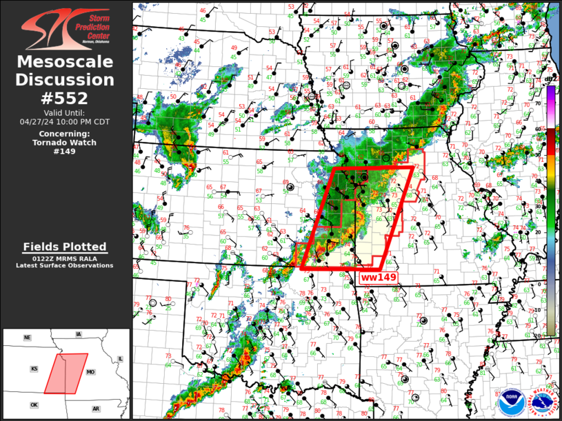
Mesoscale Discussion 0552
NWS Storm Prediction Center Norman OK
0825 PM CDT Sat Apr 27 2024
Areas affected...Southeast KS/western MO
Concerning...Tornado Watch 149...
Valid 280125Z - 280300Z
The severe weather threat for Tornado Watch 149 continues.
SUMMARY...Severe threat will gradually spread into eastern/southern
portions of ww149.
DISCUSSION...Slow-moving MCS has developed over eastern KS/western
MO early this evening. A weak MCV may ultimately evolve within this
complex near KMKC as an arcing band of convection is beginning to
surge east across Bates/Vernon County MO. Damaging wind threat may
increase ahead of this portion of the squall line. More discrete
supercells trail along the southwestern flank of the MCS across
southeast KS. As LLJ strengthens this evening, this activity should
continue propagating slowly northeast into southwest MO. Tornado
risk is highest with this southern flank activity.
..Darrow.. 04/28/2024
...Please see www.spc.noaa.gov for graphic product...
ATTN...WFO...SGF...EAX...TSA...TOP...ICT...
LAT...LON 36949634 39549531 39569269 36939380 36949634
Read more
SPC MD 551
MD 0551 CONCERNING SEVERE POTENTIAL...WATCH LIKELY FOR NORTHERN AND CENTRAL ILLINOIS
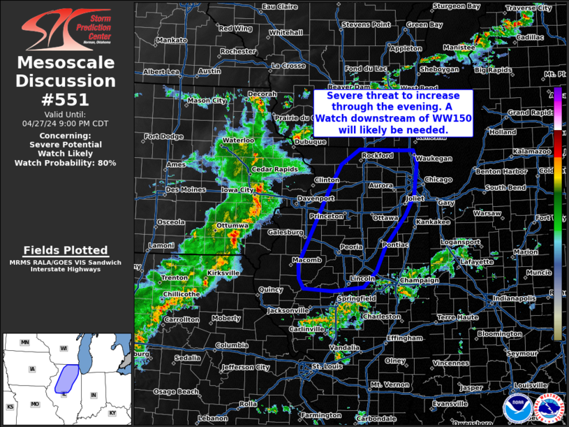
Mesoscale Discussion 0551
NWS Storm Prediction Center Norman OK
0758 PM CDT Sat Apr 27 2024

Areas affected...Northern and central Illinois

Concerning...Severe potential...Watch likely

Valid 280058Z - 280200Z

Probability of Watch Issuance...80 percent

SUMMARY...Severe threat to increase through the rest of the evening.
A Watch downstream of WW150 will likely to be needed.

DISCUSSION...A line of thunderstorms is advancing north and eastward
across southern Iowa into northeastern Missouri this evening. This
line will eventually move into portions of northern and central
Illinois, with potential for additional thunderstorm development out
ahead of this line. Ahead of this ongoing activity, temperatures
remain in the mid 70s with dew points in the low to mid-60s. MUCAPE
around 1500-1700 J/kg is observed in objective analysis data and
sounding data from the 00z RAOB from ILX. Marginal deep layer shear
around 30-35 kts suggests the main threats will be damaging wind and
hail. Ahead of the line, more discrete development aligned with the
low-level jet axis moving across central Illinois may pose the risk
of a tornado if this activity continues to mature, though low-level
lapse rates may weaken and there is uncertainty regarding this
scenario.

..Thornton/Smith.. 04/28/2024

...Please see www.spc.noaa.gov for graphic product...

ATTN...WFO...LOT...ILX...DVN...

LAT...LON   41798978 42198953 42458911 42448820 42438786 42208778
            41658786 41308807 40778852 40368873 40078901 40018972
            40059032 40059038 40229048 40479049 41798978
Read more
